Beneath the Surface: How Modern Mapping Technology Is Uncovering Tunnel Hill's Hidden Past
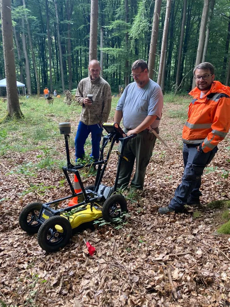
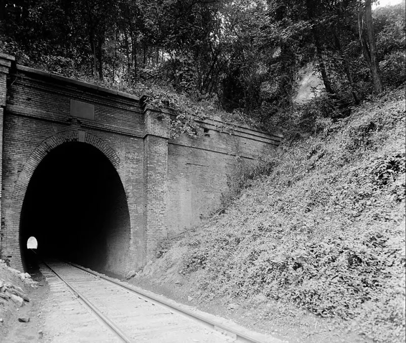
Photo: [null Courtesy], Public domain, via Wikimedia Commons
For generations, historians, archaeologists, and curious visitors have walked the grounds of Tunnel Hill trusting that what they could see represented the full measure of what once existed here. That assumption is now being systematically dismantled — not by new archival discoveries or long-lost diaries, but by instruments that peer directly into the earth itself.
Geographic information systems, more commonly known as GIS, combined with ground-penetrating radar and LiDAR remote sensing, are revealing a landscape far more complex, far more densely inhabited, and far more historically significant than surface evidence alone ever suggested. The results have surprised even seasoned researchers.
Reading the Land Like a Document
At its most fundamental level, GIS technology allows researchers to layer multiple datasets — historical maps, land surveys, property records, topographic data, and subsurface scan results — into a single, navigable digital framework. Where a traditional map offers a single moment frozen in time, a GIS model allows scholars to move fluidly across centuries, watching the landscape change, structures appear and disappear, and communities rise and dissolve.
At Tunnel Hill, this approach has proven particularly revelatory. The site's long and complicated history — encompassing industrial construction, military occupation, civilian displacement, and decades of subsequent land use — means that the visible landscape bears only a partial resemblance to what once stood here. Structures were dismantled for materials. Earthworks were leveled by farming. Communities that housed workers and their families left almost nothing standing.
GIS mapping has begun to restore what time obscured.
What Ground-Penetrating Radar Has Found
Ground-penetrating radar, or GPR, works by transmitting electromagnetic pulses into the soil and recording the signals that bounce back from subsurface anomalies — changes in soil density, buried masonry, disturbed earth, or voids that suggest former structures. The technology has been used extensively at Civil War sites across the country, but its application at Tunnel Hill has yielded findings of unusual breadth.
In one section of the site, GPR surveys identified a series of rectangular subsurface anomalies consistent with building foundations arranged in a deliberate grid pattern. Cross-referencing these findings with mid-19th-century land records and census data strongly suggests that this area once supported a small but organized residential community — likely housing for laborers involved in the tunnel's construction or the railroad operations that followed.
No structures from this settlement survive above ground. No photographs document it. Without GPR, its existence would have remained entirely speculative.
In another area closer to the historic tunnel entrance, radar surveys detected what appear to be remnants of earthen fortifications — low, wide berms characteristic of Civil War-era defensive works. These features are nearly imperceptible at ground level, eroded over more than 150 years into gentle undulations that most visitors would dismiss as natural terrain. The GPR data, however, tells a different story: these are deliberate constructions, shaped by human hands under military orders, now waiting to be more fully understood.
LiDAR and the Larger Picture
While GPR excels at detecting specific subsurface features, LiDAR — Light Detection and Ranging — offers a broader aerial perspective. By bouncing laser pulses off the ground from aircraft or drones and measuring the return time with extreme precision, LiDAR generates extraordinarily detailed elevation models that can penetrate through vegetation cover to reveal the bare earth surface beneath.
Applied to the Tunnel Hill landscape, LiDAR surveys have identified subtle topographic signatures invisible from the ground: the faint outlines of former road traces, the slight depressions that mark old well shafts or cellar pits, and the gentle linear ridges that suggest former fence lines or property boundaries. When these features are overlaid onto historical survey maps within a GIS framework, patterns emerge that allow researchers to reconstruct, with reasonable confidence, how the land was organized and used at different points in the 19th century.
The cumulative picture is one of a site far more densely occupied and organizationally complex than the present landscape implies. Tunnel Hill was not merely a construction project or a military waypoint. It was, at various moments, a functioning community — one that included workers, families, merchants, and others whose presence has been almost entirely erased from the visible record.
Connecting Technology to Living Communities
For the researchers and preservation staff at the Tunnel Hill Heritage Center, these technological discoveries carry obligations that extend well beyond academic publication. Many of the communities whose traces are now emerging from the data were composed of individuals whose stories have been systematically underrepresented in the historical record — laborers, many of them immigrants or enslaved workers, whose contributions to the site were immense but whose names and circumstances were rarely documented by those in authority.
GIS mapping cannot supply those names. It cannot restore the full texture of those lives. But it can confirm that those lives were lived here, that those communities were real, and that the land itself retains evidence of their presence. That confirmation matters, both for historical accuracy and for the descendants of those communities who have long known, through oral tradition and family memory, that their ancestors were part of this place.
Exploring the Invisible at the Heritage Center
For visitors, the most immediate opportunity to engage with these findings comes through the Heritage Center's interactive mapping installations, which translate complex GIS data into accessible, navigable visual experiences. Touchscreen displays allow visitors of all ages to peel back layers of the landscape — toggling between present-day aerial imagery, historical survey maps, and subsurface scan data to observe how the site has changed across time.
Augmented reality features, available through a dedicated Heritage Center application, allow visitors on the grounds themselves to hold up a device and observe digital reconstructions of former structures overlaid onto the actual landscape. Standing near the tunnel entrance, a visitor can watch a ghostly approximation of Civil War-era earthworks materialize against the present terrain — a visceral reminder that the past is not simply gone but rather waiting, just beneath the surface, to be seen.
Guided tours incorporating these tools are offered seasonally and are designed to accommodate both casual visitors and those with deeper historical interests. Educational programming for school groups includes hands-on introductions to GIS concepts, giving younger visitors a foundational understanding of how the same technologies used by professional archaeologists can be applied to understand any landscape.
A Landscape Still Yielding Its Secrets
The surveys conducted thus far represent only a portion of the full Tunnel Hill site. Researchers anticipate that continued scanning and analysis will surface additional features — and, almost certainly, additional surprises. The history embedded in this ground is not yet fully read.
What is already clear, however, is that Tunnel Hill's significance as a historical site extends considerably deeper than its visible monuments and preserved structures. Beneath the paths that visitors walk today lies an intricate record of human activity spanning more than a century — a record that modern technology is, at last, beginning to decipher.
The Heritage Center remains committed to making these discoveries accessible, not merely as scholarly achievements, but as living dimensions of a story that belongs to everyone who has ever had a stake in this place. History, it turns out, does not always announce itself. Sometimes it must be coaxed carefully from the ground.